Sunday 7th May - 29.3 km
Sleeping and resting until 5:00 am (Sunday), I rose to a promising dawn - by 5:15 am packing up and with the sun also up to dry the tent of dew and condensation – i.e. wet on the inside and outside – a certain amount of flysheet wafting and draping was required along with wiping. It took until 6:00 am for the first midges to appear and 6:15 am for their first bite of me – do they need to warm up to get hungry? By 6:30 am I was on my way along the road, eastwards and then south. Passing a small jetty, I admired the mists rising on the hills across the water, forming soft and wispy blanket covers on the silhouetted tops enclosing the bay of Castlebay.
 |
| Heabhal, above Castlebay, emerging from the morning mist |
Crossing to the south of this eastward projecting peninsular, there is a junction with Uidh Bhatarsaigh to the left and my route to Bhatarsaigh Baigh to the right – in the centre a triangle is enclosed by three roads, three roads emerging, three signposts and backed by three hills beyond – so I took a rather obscure 3x3 photo. Then I wondered about 3x3’s (as opposed to 4 x 4's) and considered how a 3-wheeled vehicle would fare traveling these roads with loose ridges of gravel or grass along the centre. Around 7:10 am I reached the site of the 1944 Catalina air crash - a war-time accident on a training flight in difficult weather - a memorial to those that perished and to those that survived – the survivors being more remarkable considering the state of the wreckage.

| Memorial to those that died on the 1944 Catalina air crash |
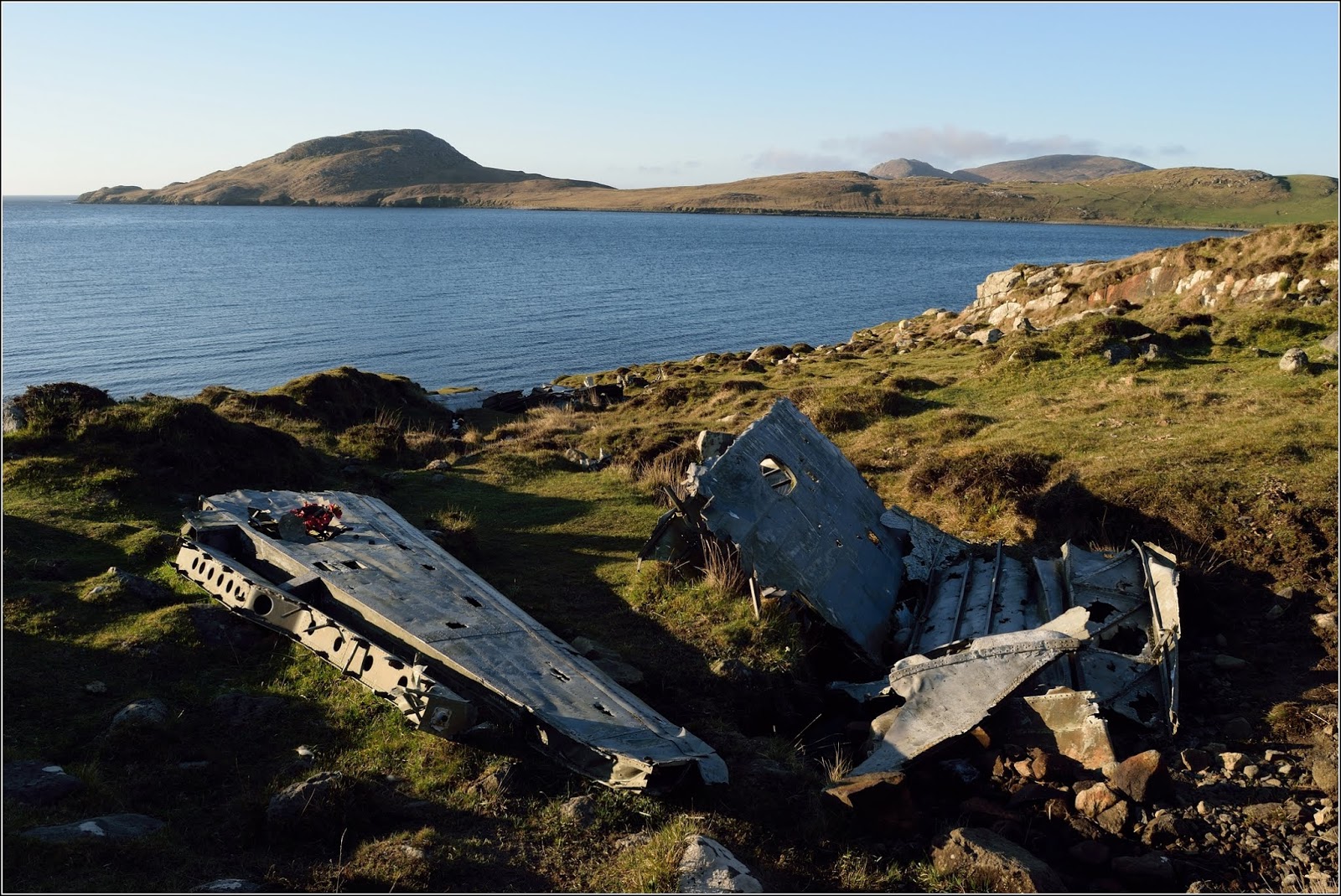
| Remnants from the Catalina air crash |

| Bhatasaigh Bagh |

| Pathway through the dunes near the Community Hall, Bhatasaigh Bagh |
 |
| An enormous anchor at the south end of Bhatasaigh Bagh |
At the end of the beach I was about to cut across the last west-pointing peninsular, but what then caught my eye was a tractor on a sloping jetty lifting a large, well filled net from the sea. I had to investigate. When I reached the point where the road ends at the top of the jetty, I found there were five men sorting crabs into crates according to gender – one of them explained and showed me how simple it was – the males have a much larger claw for fighting with – and noted that the buyers give a better price when the crabs are ready sorted. The crabs are trapped in creels on the sea bed, each creel having a rope up to a float on the surface – lifted by boat, emptied into trays, transferred into nets, kept lowered in the sea by the jetty to keep alive until lifted for mass sorting. After a bit of chat, I asked if it was OK to take some photos and they were quite content to ignore me and continue sorting while I took a few.

| Lifting a net full of crabs |

| Crab sorting |
 |
| A crab-fisherman |
Taking my time, I returned to the southern end of the beach and headed south across the south-east peninsular of Vatersay, the sandy land was festooned with primroses, especially over the grass covered dunes.
 |
| Bagh a’ Deas, Bhatasaigh (South Bay, Vatersay) |
Skylarks, lapwings and cuckoos made their contributions to both scene and audio backing. I photo’d my way around the coastline from 640938, west along Bagh a’ Deas (South Bay) to Heilinish Point (9:40 am), eating grapes all the way, and ate the orange among the rocks within 10 metres of this very exposed tip of land jutting southwards into the passage between Vatersay and Sandray; I sat in the most comfortable crevice I could find - a level rock slab, with a drop to dangle my feet over and another rock slab to rest my back against, which also shielded me from the wind. Then, propping my camera up on the rocks, I took the obligatory photo of myself, 10:00 am Sunday, 7th May, standing on this most southerly point of my walking trip and wondered about my plan – to walk northwards for 20 or more days until I reached the northernmost tip of the Isle of Lewis, some 200 miles away.
 |
| At Heilinish Point |
 |
| An orchid - orchis mascula? on the southern slopes of Beinn Ruilibreac |
Continuing west along the coastline, I was greeted by two curlews, making alarm calls, rising, passing around me in a wide circle and then departing. Then six more followed suit. Imitating their rising, circling path, I rose, gradually crossing the curved southern contours of Beinn Ruilibreac to reach a small cairn on its SSW flank. Here I could look along the length of the ‘Bishop’s Islands’ receding away on a 210-degree bearing, before rising to the top for a full 360-degree view, including Castlebay. Heading roughly NNNW, I met a very high and well barbed fence and was forced to follow it to the cliff edge. A sizable gap lay between fence and cliff edge, so it was easy to pass around the end of the fence, making me wonder why such an impenetrable barrier should be constructed with an easy access gap at its end.
No comments:
Post a Comment